
View sample Urban System In Geography Research Paper. Browse other research paper examples and check the list of research paper topics for more inspiration. iResearchNet offers academic assignment help for students all over the world: writing from scratch, editing, proofreading, problem solving, from essays to dissertations, from humanities to STEM. We offer full confidentiality, safe payment, originality, and money-back guarantee. Secure your academic success with our risk-free services.
In geography the term ‘urban system’ has a rather precise meaning: it refers to attempts to order and classify cities according to some underlying criterion or criteria. Thus, most simply, cities within any given geographical area—ranging from the local to the global—may be arrayed in terms of population size. More commonly, cities are classified in terms of the economic functions they perform; in particular, the services they provide for themselves and their surrounding areas or spheres of influence. From this comes the concept of a ‘central place system’: a system in which cities are arrayed in terms of the range of services they provide and the areas over which they provide these services. In turn this has been extended into a general urban system that forms an important part of general location theory (q.v.).
Academic Writing, Editing, Proofreading, And Problem Solving Services
Get 10% OFF with 24START discount code
1. Two Central Concepts: Rank-Size And Central Place
1.1 The Rank-Size ‘Rule’
It has long been noticed that in many parts of the world, cities and towns are quite regularly spaced. In fact, for any two adjacent towns of similar size, the distance between them is given quite well by the formula (P1/P2)/D = A, in which P1 and P2 stand for the populations of the two towns, D is the distance between them, and A is a constant for any given region reflecting general population density; thus, it is greater in Iowa than in the United Kingdom, and greater in Iowa than in Indiana (Losch 1954), but the distance between the smallest towns nevertheless seems constant for a wide range of densities. From this, it has also been shown that the distribution of towns by size follows a so-called rank-size rule: if cities are arrayed by population in descending order, then the size of the nth town is 1 n the size of the largest city, following a series: 1, 1/2, 1/3, 1/4 … 1/n (Stewart 1958).
Zipf, who first demonstrated this rule, produced a great deal of empirical justification for it, but also showed that there were many divergences from it (Zipf 1949): it works robustly for highly self-contained regions, but less so in regions where there is a great deal of interaction with other regions. This means not only that in many highly-developed parts of the world it works less well, but also that it may tend to break down over time as international trade increases. Many major cities, like London, Paris, and Tokyo, appear larger than they should do according to the ‘rule’ because they provide services for very large areas of the world, even the whole world; such cities are said to be ‘primate’ and the resulting population distribution is said to show ‘primacy.’ In other countries primate functions may be shared among two or more cities (for instance, New York and Washington within the United States, or Amsterdam, The Hague, and Rotterdam in the Netherlands, or Rome and Milan in Italy); such countries often exhibit a flattening of the top of the curve of city size distribution. Stewart’s empirical examination (Stewart 1958) showed that the five largest cities in every country showed considerable divergence from the ‘rule,’ and that even in countries which fitted better (such as the United States and Brazil), smaller subdivisions (such as states) showed major deviations from it. Other work showed that France and Mexico showed considerable divergences from the rank-size distribution, while Canada and Italy were much closer to it (Browning and Gibbs 1961).
1.2 The Central Place Hierarchy
The idea of a size–class hierarchy is related to the ranksize concept, but in a very indirect way. First, it tends to have been derived theoretically, and to have been tested empirically only later. Second, by definition ‘There is no coincidence, even theoretically, between the rank-size rule for cities and a functional size–class hierarchy of the type postulated by Christaller and Losch. The former yields a smooth descending curve of town sizes; the latter a ladder of successively lower size classes of towns, grouped around a limited number of discrete normal values corresponding to discrete functional constellations’ (Stewart 1958). Third, since the hierarchy is derived from the performance of functions, there is no necessary relationship between this measure and population size; the rather casual assumption seems to be that so many employees will be needed to provide the services, and that this total will relate generally to population numbers.
The real key to a possible relationship lies in the work of Christaller, the German geographer who first developed central place theory (Christaller 1966/1933). His basic assumption was that there was a constant relationship between the numbers of cities found at each level of the hierarchy. He suggested that the commonest relationship was one derived from service (market) areas around cities, which yielded the constant k = 3; thus, there would be one city at the topmost level, three at the next, nine at the next, and so on. But the theory also suggests a similar relationship in the sizes of cities: thus, second-level cities are one-third the size of the first-order city, and so on. Further, the market areas of all levels of city, which were hexagonal in shape because a hexagon is the figure derived from ‘packing’ circles to eliminate overlap or blank space, nested precisely within the larger hexagonal market areas of higher-order cities; the theory simultaneously established the sizes of cities, their relationships, and the sizes and shapes of their market areas.
Therefore, at k = 3, there is exact accordance with the rank-size rule. Berry and Garrison (1958a) comment that ‘The Christaller scheme is consistent with Zipf’s empirical observations, but consistency requires a rigorous choice of relationships.’ In fact, Christaller also suggested that in some cases a different value for k might apply: thus along strong transport corridors, where the key was to maximize the number of settlements along transport lines, he suggested that a ratio of k = 4 might be more appropriate, while political–social (administrative) centers were governed by the principle of separating regions administratively, suggesting a ratio of k = 7. So the correspondence with the rank-size rule applies only in the one special case, albeit the one that appears to be the most common one.
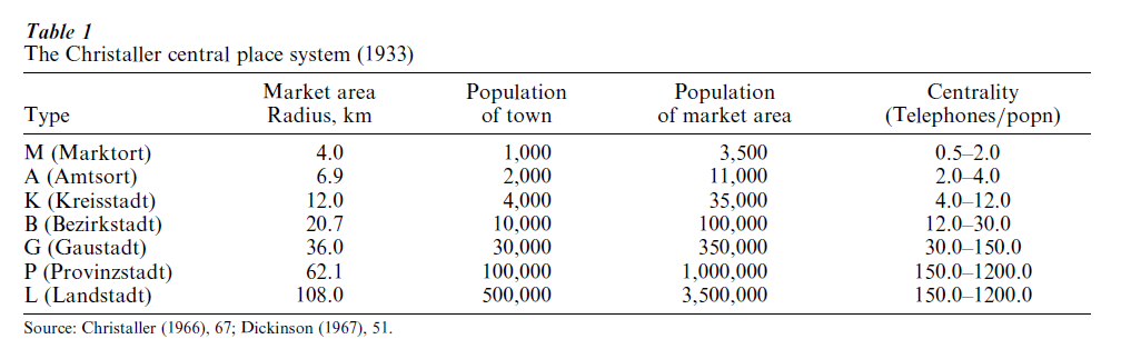
Christaller derived the theory from pure principles, but then sought to confirm it empirically. Curiously, he based this work largely on the number of telephone connections in each city, particularly their ratio to the city’s population. He developed a sevenfold hierarchy (Table 1). His map shows that over wide areas the marketing principle appears to work satisfactorily, but it is modified in practice by transport lines and by basic variations in natural resources which affect population density. Further, especially at higher levels, political history may be significant: thus, Munich, which is set at the highest theoretical level (Landstadt), is in fact intermediate between this level and an even higher one, not represented in this region, Reichstadt or national capital, because Munich was for centuries the capital of the independent state of Bavaria before being embodied in a unified Germany in 1871.
Subsequent to Christaller, but before translation of his work into English, British and North American geographers made a number of studies of national urban hierarchies. In Great Britain the most notable are by Smailes (1944, 1946, 1947), Carruthers (1967) and Smith (1968, 1970, 1978). Below London, regarded as a unique case, Smailes distinguished only five hierarchical levels (major cities, cities, minor cities, towns, and subtowns; Carruthers distinguished eight, and Smith (who used a similar scheme to Carruthers’) 10). All these studies were strictly empirical, and interestingly made no reference to Christaller. The North American studies tended to concentrate on low-density agrarian regions such as Iowa, South Dakota, Washington State, and Saskatchewan, and therefore did not distinguish a complete range of upper-order settlements; comparing Southwestern Wisconsin and Southern England, Brush and Bracey were able to distinguish only two levels of service center (Berry and Garrison 1958a, Berry and Parr 1988, Brush and Bracey 1955, Hodge 1965). However, Berry extended the principle to Chicago and its suburbs, where he found a systematic hierarchy of centers and subcenters, albeit strongly arrayed along major radial transportation lines (Berry 1963, Berry and Parr 1988).
1.3 Towards A General Urban-Location Theory: The Work Of August Losch
Six years after Christaller, a German economist sought to extend his work (and that of others, such as Alfred Weber on industrial location and Johann Heinrich von Thunen on agricultural location) into a general theory of economic location. Specifically, he secured an ingenious combination of Christaller’s market and transport principles: starting with a distribution of hexagonal market areas around a single (first-order) metropolitan center, he rotated them so as to obtain six sectors with many production sites, and six with only a few, their boundaries established by six through transport lines that radiated through the central metropolitan city. He could, thus, argue that city distributions and sizes are different in transport-rich and transport-poor sectors. (He argued that Christaller had been mistaken in distinguishing the market and transport principles; this was due to an accident, that when k 3 all places lie symmetrically with respect to the six through transport lines, so that no thickly or thickly settled areas appear.) Depending on the basic assumptions made, the middle or two outer segments in transport-poor sectors would have few towns. But in addition, the immediate environs of the metropolis would be city-poor, because only a few local goods could be profitably produced there (Losch 1954).
Losch described the resulting arrangement as an economic landscape. He gave only two sketchy empirical illustrations, based on two midwestern American cities (Indianapolis and Toledo), and nowhere attempted a rigorous proof. And, because his system is much more complex than Christaller’s (though superficially similar; Losch does not accept Christaller’s basic principle that lower-order areas nest within larger ones, but derives them all independently), it is inherently more difficult to demonstrate empirically. However, subsequent work, notably that of Berry on Iowa and by Hodge on the northern Great Plains of Canada, suggests that in these quintessential agricultural areas, the central place system essentially developed along rail lines as they were built (Berry and Parr 1988, Hodge 1965).
2. The Dynamics Of Urban Systems
Christaller himself recognized that central place patterns would change over time, for instance, because of new transport connections, especially in the modern era (Christaller 1966); the pattern of cities would be set by the original transport mode, but their relative significance might change as new modes emerged, and also as wider ranges of goods came to be traded. He wrote: ‘We observe a very great frequency of places called towns and market spots; and we may consider the central places of ancient times, of the Middle Ages, and of modern times, the results of the economic conditions, values, and production of each period’ (Christaller 1966). However, he did not try to demonstrate this rigorously. Subsequent work has suggested that urban hierarchies can change in three possible ways: in their initial establishment (top-down or bottom-up); later, through changes in the level at which an individual function is supplied; and through changes in the basic structure of the hierarchy, either in terms of the numbers of levels or the numbers of centers belonging to a given level (Berry and Parr 1988). Empirical work has shown, for instance, that in North America, improved transportation—especially the spread of automobile use—caused small trade centers to decline faster than large ones, though the decline did not increase regularly down the scale (Hodge 1965). Some work has been done to incorporate observations of this kind into formal models (Parr and Denike 1970, Mulligan 1980).
3. From Central Place Systems To General Systems Theory
The final question has to be whether central place systems can be generalized into General Systems Theory. A system can be regarded as containing: a set of objects (central places), their attributes (e.g., population); inter-relations among objects (e.g., locations); inter-relations among attributes (e.g., logarithmic relationships); and interdependencies between objects and attributes (e.g., a hierarchy). Systems can be closed and open. In a closed system, available energy is dissipated gradually until it becomes random through the system; it will have reached a state of maximum entropy, in which all trace of hierarchy had disappeared. Several attempts have been made to analyze central place systems in this way. An open system in contrast will settle into an equilibrium between the tendency to maximize entropy and the need for organization; this is known as a ‘steady state.’ Most central place systems correspond to this model, and it is expressed by rank-size regularity, which will tend to persist over time (Berry and Parr 1988).
However, the central place system is only a part of the wider urban system; ‘there are many aspects of the economic and social organization of urban systems that are wholly beyond the scope of central-place theory’ (Berry and Parr 1988). In 1977 Pred argued that ‘In conventional geographic and planning literature on systems of cities excessive emphasis is placed on the hierarchical structure of interdependencies’, which‘is highly unrealistic as a description of the total structural composition of city-system interdependencies in advanced economies’ (Pred 1977). This, Pred argued, was because in the Christaller system the largest urban unit was required to be completely self- reliant, because there could be no interdependence between large cities in the form of lateral exchanges of goods and services between second or third-order cities, and because finally each ‘nesting’ arrangement below a single first-order places is effectively a closed system. The Losch system performed rather better because it did allow lateral exchanges, but it too required the top-order city to be totally self-supporting. In the real world, ‘the most critical growth-generating city-system interdependencies in economically advanced countries are largely the product of input-output relationships, or of job-control and decision-making relationships within multilocational business and government organizations’ (Pred 1977).
Pred sought to demonstrate in detail how such interdependencies had developed historically in the American urban system between 1790 and 1910. In his account, access to specialized information plays a crucial and increasingly important role. Because the largest cities early acquire privileged access, even in the era before the telegraph or railroads, they tend to maintain it with each successive technological advance. This sets up a system of positive multipliers and positive feedback loops which tend to consolidate and enhance their position. Pred shows that to a remarkable degree, in advanced industrial countries the rank ordering of cities has remained stable over a long period; in the United States, where new cities arose during the western expansion, the rule is nevertheless true for each major regional division (Pred 1977). He concludes that there is a ‘tendency of early established major channels of interdependence, or interurban growth transmission, to be self-reinforcing, thereby becoming increasingly entrenched and influencing subsequent channels of interurban growth trans-mission’ (Pred 1977). However, city-systems in different countries do demonstrate very different patterns and trajectories, depending on different histories; there is an instructive contrast here between France, with its highly centralized history, and Australia, whose city system essentially derives from its colonial past.
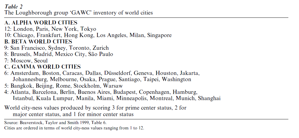
A key question concerns change at the top of the hierarchy. Most studies within the central place paradigm, including Christaller’s, do not even provide specifically for a national metropolitan centre. But globalization appears to result in centers with a global range (Castells 1989, Sassen 1991). It would appear that centers are in effect dropping out at the bottom of the hierarchy and are being added at the top. Hall (1999) has suggested that the two bottom levels of the Christaller hierarchy have in effect disappeared from the hierarchy, becoming mere villages, while a global and a subglobal level have been added at the top. Research by Beaverstock and Taylor suggests that global-level cities can be distinguished both by key attributes (such as concentrations of specialized services) and by relationships (such as exchanges of personnel). The latter are more significant but are more difficult to measure, since data are often not available. But they use data on branch offices of specialized financial and business services to establish a new hierarchy based on an index of ‘globality’ (Table 2) (Beaverstock et al. 1999). The significance is that this research rather precisely illustrates the Pred hypothesis: that, in a world increasingly based on the exchange of specialized information, the relationships are increasingly horizontal in terms of the hierarchy of cities, and global in scale. Without doubt, central place systems have been a useful conceptual device, and they still illustrate important features of the modern world (for instance local trading and commuting systems). But, for a fuller understanding, the need for the future is to integrate them into a wider systems framework.
Bibliography:
- Beaverstock J V, Taylor P J, Smith R G 1999 A roster of world cities. Cities 16: 445–58
- Berry B J L 1963 Chicago Commercial Reference Handbook. University of Chicago Press, Chicago
- Berry B J L 1964 Cities as systems within systems of cities. Papers, Regional Science Association 13: 147–63
- Berry B J L, Garrison W L 1958a Alternate explanations of urban rank-size relationships. Annals of the Association of American Geographers 48: 83–91
- Berry B J L, Garrison W L 1958b The functional bases of the central-place hierarchy. Economic Geography 34: 145–54
- Berry B J L, Parr J B 1988 Market Centers and Retail Location: Theory and Applications. Prentice-Hall, Englewood Cliffs, NJ
- Browning H L, Gibbs J P 1961 Some measures of demographic and spatial relationships among cities. In: Gibbs J P (ed.) Urban Research Methods. Van Nostrand, Princeton, NJ, pp. 436–59
- Brush J E, Bracey H E 1955 Rural service centers in Southwestern Wisconsin and Southern England. Geographical Review 45: 559–69
- Carruthers W I 1967 Major shopping centres in England and
- Wales, 1961. Regional Studies 1: 65–81
- Castells M 1989 The Informational City: Information Technology, Economic Restructuring and the Urban-Regional Process. Blackwell, Oxford, UK
- Christaller W 1966/1933 Central Places in Southern Germany (Trans. Baskin C W). Prentice-Hall, Englewood Cliffs, NJ
- Hall P 1999 The future of cities. Computers, Environment and Urban Systems 23: 173–85
- Hodge G 1965 The prediction of trade center viability in the Great Plains. Papers and Proceedings of the Regional Science Association 15: 87–115
- Losch A 1954 The Economics of Location. Trans. Woglom W H, Stolper W F. Yale University Press, New Haven, CT
- Mayer H M, Kohn C F (eds.) 1959 Readings in Urban Geography. University of Chicago Press, Chicago, pp. 230–39
- Mulligan G F 1980 The effects of multiplier shifts in a hierarchical city-size model. Regional Science and Urban Economics 10: 77–90
- Parr J B, Denike KG 1970 Theoretical problems in central place analysis. Economic Geography 46: 567–86
- Pred A 1977 City-System in Advanced Economies: Past Growth, Present Processes and Future Development Options. Hutchinson, London
- Sassen S 1991 The Global City: New York, London, Tokyo. Princeton University Press, Princeton, NJ
- Smailes A E 1944 The urban hierarchy in England and Wales. Geography 29: 41–51
- Smailes A E 1946 The urban mesh of England and Wales. Transactions of the Institute of British Geographers 11: 84–101
- Smailes A E 1947 The analysis and delimitation of urban fields. Geography 32: 151–61
- Smith R D P 1968 The changing urban hierarchy. Regional Studies 2: 1–19
- Smith R D P 1970 The changing urban hierarchy in Wales. Regional Studies 4: 85–96
- Smith R D P 1978 The changing urban hierarchy in Scotland. Regional Studies 12: 33–351
- Stewart C T Jr 1958 The size and spacing of cities. Geographical Review 48: 222–45
- Zipf G K 1949 Human Behavior and the Principle of Least Effort. Addison-Wesley, Cambridge, MA
ORDER HIGH QUALITY CUSTOM PAPER

Always on-time

Plagiarism-Free

100% Confidentiality